
- This event has passed.
David Rumsey Map Islands
31/12/2021 @ 7:00 AM - 8:00 AM PST
Free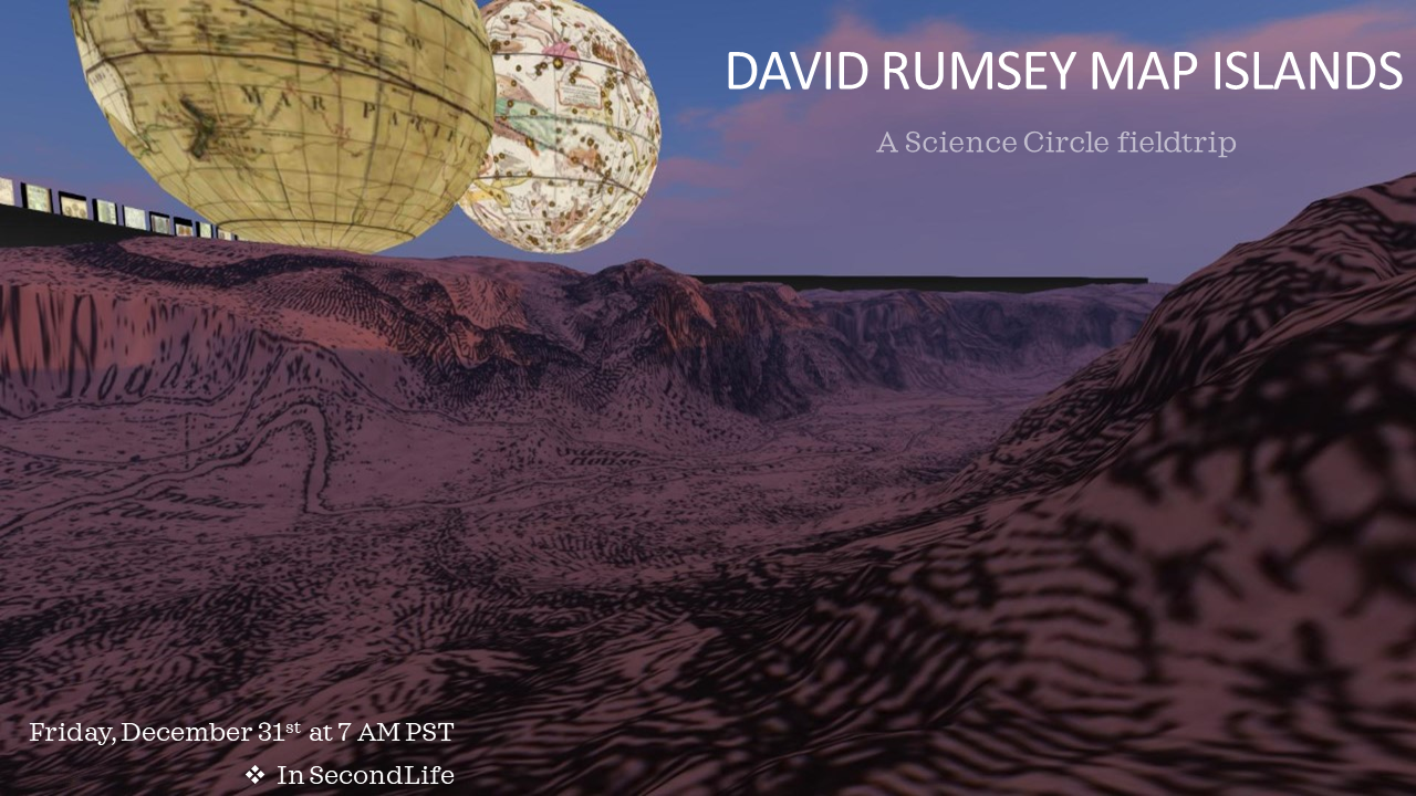
Image credits to the “David Rumsey Map Collection Center,” from Stanford Libraries in Second Life.
David Rumsey donated his entire physical map collection to Stanford University, where it is housed in the David Rumsey Map Center at the Stanford University Library.
David Rumsey Cartography Map Islands
Today we visit these four beautiful regions and it is advisable to read the accompanying description below in advance. These regions offer different cartographic visualizations and activities. You can also use a “Flight pack” to facilitate navigation in the regions.
ABOUT DAVID RUMSEY MAP COLLECTION
The David Rumsey Collection was started nearly 20 years ago, and focuses primarily on cartography of the Americas from the 18th and 19th centuries, but also has maps of the World, Asia, Africa, Europe, and Oceania. The collection includes atlases, globes, school geographies, books, maritime charts, and a variety of separate maps, including pocket, wall, children’s and manuscript.
Digitization of the project began in 1997. The project was undertaken for numerous reasons: Maps are uniquely suitable to high-resolution scanning because they contain large amounts of detailed information, which can be seen more readily when the viewer is able to zoom in and enlarge images on a computer screen. Viewed over the Internet, rare maps become available to those who previously had no access to such collections or were not aware of the maps’ existence. In their original form, maps and atlases can be large, delicate, and unwieldy. Digitization increases their accessibility, and combined with an online catalog allows the viewer a variety of ways to search the collection.
Presenting individual maps in a digital format literally breaks the boundaries of an atlas’s bookbinding, allowing the viewer to view single maps independent of their original encasing. With Luna Imaging’s Insight® software, the maps are experienced in a revolutionary way. Multiple maps from different time periods can be viewed side-by-side. Or, the end user can create their own collection of maps by saving groups of images that hold particular interest. Complete cataloging data accompanies every image, allowing for in-depth searches of the collection.
Materials that were created in America and that illustrate the evolution of the country’s history, culture, and population distinguish the collection. Close inspection of the maps often reveals the rise and fall of towns, mining excavations, the unfolding of the railroads, and the “discovery” of the American West by European explorers. The collection also includes European imprints containing maps of the Americas that were influential to American cartographers, as well as maps of other parts of the world distinguished by great craftsmanship, significance and beauty.
ABOUT CARTOGRAPHY ASSOCIATES
Cartography Associates, founded in 1996, promotes the distribution of digital facsimiles both in print and electronic media. Specializing in both primary source documents and cutting-edge technology, Cartography Associates is committed to developing tools that integrate cataloging with visual images on the Internet. CA’s vision is to offer users the best of both worlds: the powerful searching, access, and user functionality made possible by technology, combined with the visual beauty, technical mastery and intellectual richness of original source materials.
COPYRIGHT INFORMATION
Images copyright © 2000 by Cartography Associates. Images may be reproduced or transmitted, but not for commercial use. For commercial use or commercial republication, contact carto@luna-img.com. This work is licensed under a Creative Commons License. By downloading any images from this site, you agree to the terms of that license.
——————————————————-
THE WELCOME GIFTSHOP
——————————————————-
FIRST FLOOR:
8 dynamic map viewers. These map viewers allow you to look at maps in great detail. You can pan and zoom maps by clicking on the buttons associated with each task.
SECOND FLOOR:
Free giveaways. David Rumsey has offered to giveaway 40 various maps for use in your SL home as wall hangers. In addition to these beautiful maps, we have also created some fun objects as well. Orrery’s and globes can be used in your library or home for decorative purposes. A great way to take the experience home with you.
——————————————————-
WORLD MAP – PUSH PIN ANNOTATION
——————————————————-
We love hearing where people come from. The world map that sits outside the gift shop build is a dynamic map that allows public annotation. Simply click on any surface of the world map to rez 1 push pin. Then follow these instructions.
– Locate your hometown.
– Click on the surface of the world map to rez a red map pin.
– Touch and hold the push pin, then move it to your hometown.
– Type in the name of your hometown.
– Type in your comments > hit enter.
– Your comments are now tagged onto the map for everyone to read.
——————————————————-
YOSEMITE TERRAIN
——————————————————-
While you are here, you will notice that the entire region is covered in a map terrain. The map you are looking at is a map of Yosemite. The terrain elevation you are also looking at is “real terrain” brought into SL by utilizing real topography height elevation models. In essence you are really flying through Yosemite. If your avatar was about 3 inches tall, this entire estate would represent a 1:1 scale.
As you near the center of the estate you will see a circle platform that houses some controls. You can set the bright effects, and alpha effects of each sim. Try clicking on “elevation off” to see the map represented as a flat map.
——————————————————-
CELESTIAL & GLOBE SPHERES
——————————————————-
Our estate houses 2 large spheres. These spheres are impressive in size, and level of detail. Explore the world globe, or gaze into the celestial skies. You can even fly inside of it (phantom) and see what’s hidden inside.
——————————————————-
GRAND CANYON PARRALAX
——————————————————-
The grand canyon illustration that you see framed on our sim has very impressive details. The sense of depth in this image is amazing, so we decided to show it as a layered parralax so that you can appreciate its sense of depth.
——————————————————-
OLD NEWYORK 1836
——————————————————-
Explore the streets of NYC in 1836. This map has superb detail, down to the street level. While you are viewing the map, try changing camera angles to look at it straight on. You can also sit on the map pointers.
– Right click and sit on the map pointer (choose a color)
– Click on the map pointer color that you are sitting on.
– Mouselook tab should appear. When this does, use your arrow keys to move around the map.
– When done, simple click on the “standup” tab.